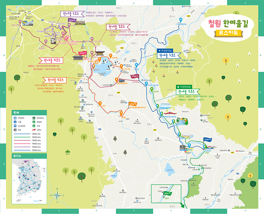
Hanyeoul course 1 offers a beautiful natural view of the Hantan River basin and an unusual wildlife ecosystem in the only basalt area on the Korean Peninsula, as well as experiencing the traces of the history of the Korean War and division.
In addition, visitors can enjoy unique experiences such as numerous migratory birds visiting the vast Cheorwon Plain.
Geo Trail
Geo Trail
Hanyeoul-gil
- Byeorut-gil
- Dulle-gil
- Eoul-gil
- Culture and Eco Trail
- Chatancheon Roundabout
- Yeongang Narut-gil
- Imjin Red Cliff Road
- Hantan River Columnar Joint Road
- Hapsumeori Ggokji-gil
- Hanyeoul-gil
1 Course
-
Course :
- Seungilgyo Park
- Goseokjeong
- Madang Rock
- Songdaeso
- Taebong Bridge
- Jiktangpokpo Falls
- Chilmanam
- Total distance :11km
- Total required time :3 hour
Characteristics: Selected as the Culture & Ecology Tour Course in 2010 by the Ministry of Culture, Sports and Tourism
2 Course
-
Course :
- Seungilgyo
- Yangsujang
- Songdaeso
- Taebong Bridge
- Jiktangpokpo Falls
- Witsangsari
- Total distance :5.1km
- Total required time :2 hour
Hanyeoul course 2 is a walking path that is consisted of Seungil Bridge to Madang Rock, paddy pathes, columnar joints, and Forest Roads in the first section, which allows visitors to experience the Hantan River through the connected second section of basalt rock Zone and Taebong Bridge with a variety of wild flowers and the surrounding scenery.
Hanyeoul 2 course has a wide range of plant groups and lets you pass the viewpoints of the Hantan River's columnar joints and Jiktang Falls, which is the 'Korea's Niagara Falls'.
3 Course
-
Course :
- Deokgogae village
- Hak Reservoir
- Stepping bridge
- Dopiansa Temple
- Road to Geumgangsan Mountain
- Korean Workers' Party Headquarters
- Saewujeot Hill
- Yongdam Village
- Baengmagoji Station
- Total distance :11km
- Total required time :3 hour
Characteristics: Selected as the Culture & Ecology Tour Course in 2010 by the Ministry of Culture, Sports and Tourism
The main transportation point where Gyeongwon Line(Railroad) and Mount Geumgang meet is where you can find the modern cultural relics such as Cheorwon-eup and the Labor Party Office, those which have faded into history.
This road, where the painful scars of war and division and the generous human heart of the countryside coexist, is a rather arduous journey which requires a lot of legwork with patience and perseverance.
4 Course
-
Course :
- Cheorwon-gun Hyanggyo
- Direction milestone
- Dongjusanseong Fortress Observatory
- Dongjusanseong Fortress Roost
- Saewujeot Hill
- Total distance :3.5km
- Total required time :1 hour
This trail was built along the mountain ridges of Wolha-ri and Gwanjeon-ri villages in Cheorwon, near the DMZ northwest of Cheorwon-gun. Wolha-ri is a time-honored place, where the residence of Wang Geons(the founder of Goryeo), is estimated to be located. Gwanjeon-ri is the place where was located in the downtown with public offices and shopping centers during the Japanese Colonial Rule, and the population reached 20,000 in that period. Gwanjeon-ri is also a place where Songgang Jeongchol sang about King Taebong's rise and fall and the futility of time during the Joseon Dynasty, through his song Gwandong-byulgok at Bukgwanjeong, which is located in the northern part of the village. The thousand-year-old history and the joys and sorrows of life is contained in this Green Path of Cheorwon-gun.
5 Course
-
Course :
- Jirweggot-gil Entrance
- Jirweggot-gil
- Ecology Forest-gil
- Bongsudae Oreum-gil
- Soisan Mountain Entrance
- Total distance :4.8km
- Total required time :2 hour
Hanyeol course 5 is divided into three sections: "Gwanggye Flower Road" along the unidentified mine area north of Mt. Soisan, "Soisan Ecological Forest Road," which is full of trees and wild flowers, and provides a glimpse of the biggest battleground during the Korean War, and "Bongsudae Oreum-gil," which was a military operation until a few years ago. The area has been closed to civilians for 60 years, and the ecosystem is well preserved.
6 Course
-
Course :
- Daegyocheon Ecology Park
- Odeokgyo Bridge
- Hak Reservoir
- Dongju Choi’s Baedan
- Gaegurisan Mountain
- Deokgogae Village
- Cheorwon-gun Hak Village Center
- Total distance :3.5km
- Total required time :1 hour
The course starts from Daekyocheon Ecological Park and continues along Daekyo Stream until the Hak Reservoir Ecology Trail. The course offers a beautiful and eyecatching view of the reservoir. The scenery of Cheorwon's village can also be observed, and the various story-telling courses give you a fun, interesting walk.